Įjungti/išjungti naršymo
Paieška
Australija
daugiau apie šią
šalį
Afganistanas
Airija
Albanija
Alžyras
Amerikos Samoa
Andora
Anglija
Angola
Antigva ir Barbuda
Argentina
Armėnija
Aruba
Australija
Austrija
Azerbaidžanas
Bachreinas
Bahamų Sandrauga
Baltarusija
Bangladešas
Barbadosas
Belgija
Belizas
Beninas
Bermuda
Bisau Gvinėja
Bolivija
Bosnija ir Hercogovina
Botsvana
Brazilija
Brunėjus
Bulgarija
Burkina Fasas
Burundis
Butanas
Centrinė Afrikos Respublika
Čadas
Čekija
Čilė
Danija
Didžioji Britanija
Dominika
Dominikos Respublika
Džersis
Džibutis
Egiptas
Ekvadoras
Eritrėja
Estija
Etiopija
Farerų salos
Fidžis
Filipinai
Folklando (Malvinų) salos
Gabonas
Gajana
Gambija
Gana
Gernsis
Gibraltaras
Graikija
Grenada
Grenlandija
Gruzija
Guamas
Gvadelupa
Gvatemala
Gvinėja
Haitis
Hondūras
Honkongas
Indija
Indonezija
Irakas
Iranas
Islandija
Ispanija
Italija
Izraelis
Jamaika
Japonija
Jemenas
Jordanija
Jungtiniai Arabų Emiratai
Jungtinės Amerikos Valstijos
Juodkalnija
Kabo Verdė
Kaimanų salos
Kalėdų salos
Kambodža
Kamerūnas
Kanada
Kataras
Kazachija
Kenija
Kinija
Kipras
Kirgizija
Kiribatis
Kokosų (Kilingo) salos
Kolumbija
Komorų salos
Kongo Demokratinė Respublika
Kongo Respublika
Kosta Rika
Kot di vuara
Kroatija
Kuba
Kuko salos
Kuveitas
Laosas
Latvija
Lenkija
Lesotas
Libanas
Liberija
Libija
Lichtenšteinas
Lietuva
Liuksemburgas
Madagaskaras
Majotas
Makao
Makedonija
Malaizija
Malavis
Maldivai
Mali
Malta
Marianos Šiaurinės Salos
Maroko
Maršalo salos
Martinika
Mauricijus
Mauritanija
Meksika
Mianmaras (Birma)
Mikronezijos Federacinės Valstijos
Moldova
Monako
Mongolija
Monseratas
Mozambikas
Namibija
Naujoji Kalėdonija
Naujoji Zelandija
Nauru
Nepalas
Niderlandai
Niderlandų Antilai
Nigerija
Nigeris
Nikaragva
Niujė
Norfolkas
Norvegija
Omanas
Pakistanas
Palau
Panama
Papua Naujoji Gvinėja
Paragvajus
Peru
Pietų Afrika
Pietų Korėja
Pitkerno salos
Portugalija
Prancūzija
Prancūzų Gviana
Prancūzų Polinezija
Puerto Rikas
Pusiaujo Gvinėja
Reunjonas
Ruanda
Rumunija
Rusija
Rytų Timoras
Salomono salos
Salvadoras
Samoa
San Marinas
San Tomė ir Prinsipė
Sant Lusija
Saudo Arabija
Seišelių salos
Senegalas
Sent Kitsas ir Nevis
Sent Pjeras ir Mikelonas
Sent Vinsentas ir Grenadinai
Serbija
Siera Leonė
Singapūras
Sirija
Slovakija
Slovenija
Somalis
Sudanas
Suomija
Surinamis
Svalbardas
Svazilandas
Šiaurės Korėja
Šri Lanka
Švedija
Šveicarija
Šventos Elenos salos
Tadžikija
Tailandas
Taivanas
Tanzanija
Terksas ir Kaikosas
Togas
Tokelau
Tonga
Trinidadas ir Tobagas
Tunisas
Turkija
Turkmėnija
Tuvalu
Uganda
Ukraina
Urugvajus
Uzbėkija
Vakarų Sachara
Vanuatu
Venesuela
Vengrija
Vietnamas
Virdžinijos salos (JAV)
Vokietija
Volisas ir Futūra
Zambija
Zimbabvė
Kanbera
daugiau apie šį
miestą
Adelaidė
Albany
Albury-Wodonga
Baird Bėjus
Balaratas
Ballina
Bendigo
Brisbenas
Bunbury
Bundaberg
Busselton
Byron Bay
Coffs Harbour
Darvinas
Devonport
Geelong
Geraldton
Gladstone Tannum Sands
Gosfordas
Hervey Bay
Hobartas
Kanbera
Kaunas
Kernsas
Kewarra paplūdimys
Launceston
Makėjus
Melnburnas
Mildura Wentworth
Niukaslas
Oranžinė
Pertas
Ravenšu
Rockhampton
Shepparton-Mooroopna
Sidnėjus
Tamworth
Taunsvilis
Toowoomba
Traralgon Rangiora
Wagga Wagga
Wollongong
Registracija
Kontaktai
Gabo Island Airport
Australija
List of airports Australija
Gabo Island Airport
Informacija apie oro uosto - Gabo Island Airport, Australija
Aprašymas
Vertė
IATA
(IATA oro uosto kodas)
IATA kodas
Tipo
Nedidelio oro uosto
Vietos oro uosto kodas
-
GPS oro uosto kodas
YGBO
Rytų ilgumos
-37.5666999816895
Šiaurės platumos
149.899993896484
Nuotraukos – Gabo Island Airport, Australija
Nuotraukos Gabo Island Airport
Informacinė medžiaga - Kanbera
Kainos, pragyvenimo išlaidos Kanbera
Laikas Kanbera
Laiko juosta - Kanbera, Australija
Orai - Kanbera, Australija
Kanberos žemėlapis
Nacionalinės vėliavos Australija
Kanbera - telefono kodas, kaip paskambinti Kanbera
Nuotraukos Kanbera
Nuo Kanbera, Australija
Informacinė medžiaga - Australija
Piniginis vienetas Australija, Australijos doleris
Valiutos skaičiuoklė Australijos doleris
Ambasados Australija
Australijos žemėlapis
Oro uostų sąrašą Australija
Foto galerija
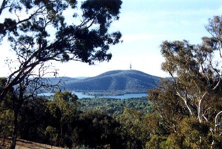
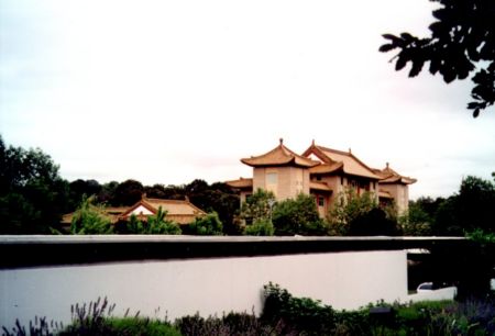
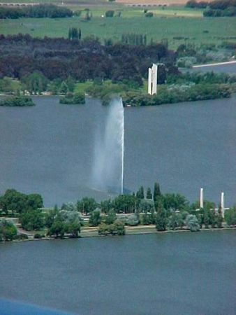
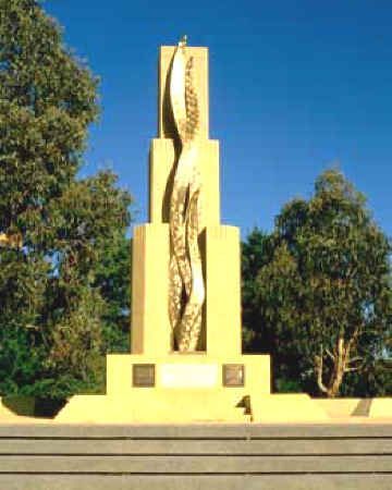
Australija, Kanbera
Pridėti foto
Nuotraukos Kanbera »